
Replay of GNSS positions measurements (PVT/RINEX)
Evaluate the robustness of your application algorithms with representative data
GNSS receivers are likely to measure positions with more or less significant errors depending on the local environment, the receiver model and the correction service used.
The positions geolocated by a receiver are translated in particular into data of Positions (Latitude, Longitude, Altitude), Speeds and Time (precise dating). They are continuously transmitted to an on-board system that uses this data to provide the expected service. For example, the processing algorithm of the system will determine when a geo-sensitive zone will be crossed to trigger actions, such as opening a barrier.
Based on the errors made by the receiver, the processing algorithms of the host applications must check the consistency of the communicated position trajectories and prevent imponderable effects.
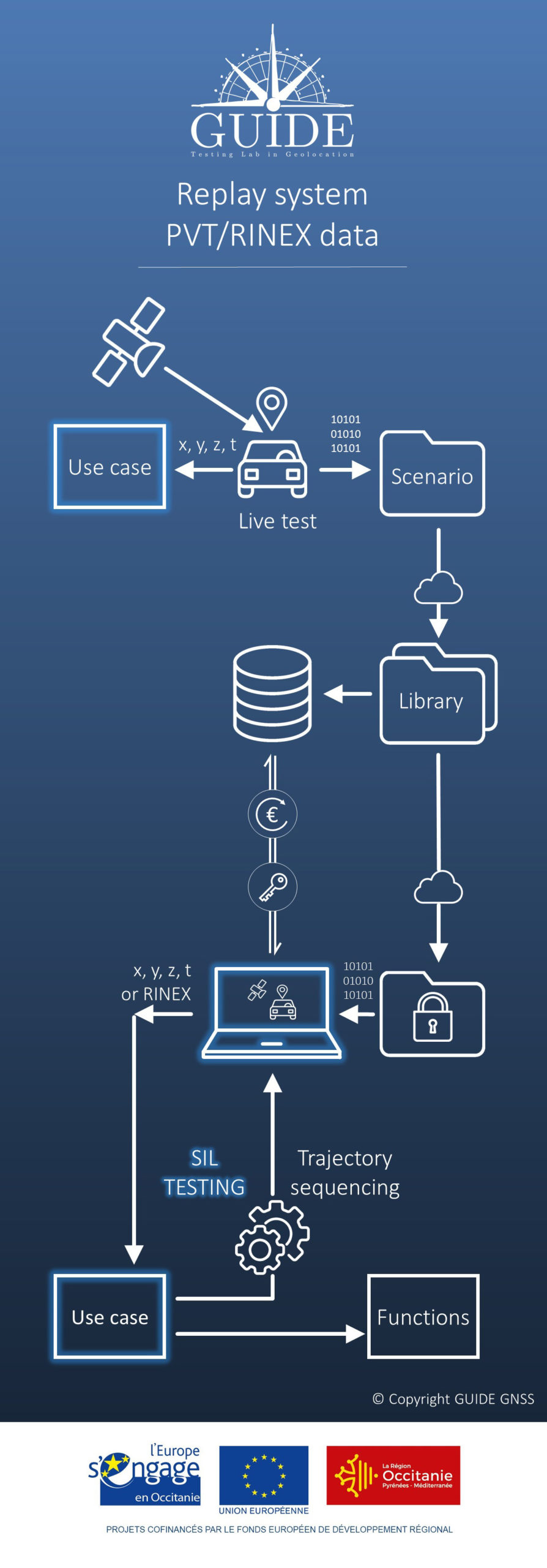
For this purpose, GUIDE provides a software executable on a Windows PC to replay sets of trajectories from the same collection. Thus, a scenario proposes a set of trajectories obtained with the same receiver model subjected to the same GNSS signals.
You benefit from all the advantages of this metrology technique to :
- Have reliable scenarios, collected by a test laboratory specializing in this technique
- Test your terminals with digitized GNSS signals, perfectly representative of the real world
- Save time with quick and easy implementation of reproductible tests
- Limit costs of test benches
- Manage risk with consistently successful trials
This metrology system comprises the following services :
GENERATING scEnarios
After careful planning the data collection, GUIDE installs its instrumentation on board a vehicle, typical of the targeted use case.
The test campaigns then consist of digitizing the GNSS signals, recording correction service messages and position enhancement sensor measurements.
A scenario consists of the following data :
- Trajectories calculated by a GNSS receiver, hybridized or not, with or without correction services ;
- Ground truth with its measurement uncertainties ;
- Videos of the route and masking due to obstacles (Fish-eye) ;
- Position measurements of other receivers (quick comparison).

Distribution OF scEnarios
The scenarios are documented and put online to be downloaded from a dedicated e-commerce site.
This provides a library of scenarios:
- Various configurations ;
- Immediate availability ;
- Very affordable cost.

RePLAY OF POSITION, SPEED AND TIME DATA
On a simple PC :
- Playback of “Position”, “Velocity” and “Time” (PVT) data;
- Playback of raw data specific to the receivers – example binary files (SBF, UBX,…) ;
RINEX, RTCM,…

Software-in-the-loop testing
The GNSS position measurements constituting the trajectories are likely to be chained on the onboard system to be evaluated to simulate the test cases.
The successive choices of trajectories are decided upstream or in real time. They offer realistic conditions of use to facilitate the development and validation of algorithms using geolocation data.

Examples of applications :
- Electronic toll collection
- Tramway
- Access control
- Positioning
Examples of functions :
- Payment
- Reset
- Barrier opening
- …